
Cupix Features
Features & Benefits
EFFECTIVELY AND EASILY SCALABLEProvides an EASI method using any 360 capable camera and a smart device to produce one digital twin or many. |
INTEGRATE ALL VISUAL FILE TYPESCompile all 2D, 3D and Lidar data, importing existing and new data into our cloud based platform. |
HARDWARE AGNOSTICCupix allows you to use your own devices, so there are no major hardware expenses involved. |
SECURE CLOUD STORAGECupix is based on AWS cloud servers which allows all data to be shared collaboratively with many stakeholders safely via built in roles and permissions. |
CAPTURECreate a virtual 360° walkthrough of your facility and compile every view of your physical space into a singular composite. |
|
Software
Full 3D cloud-based SAS platform to easily share secure data among internal and external stakeholders for effective digital asset management.
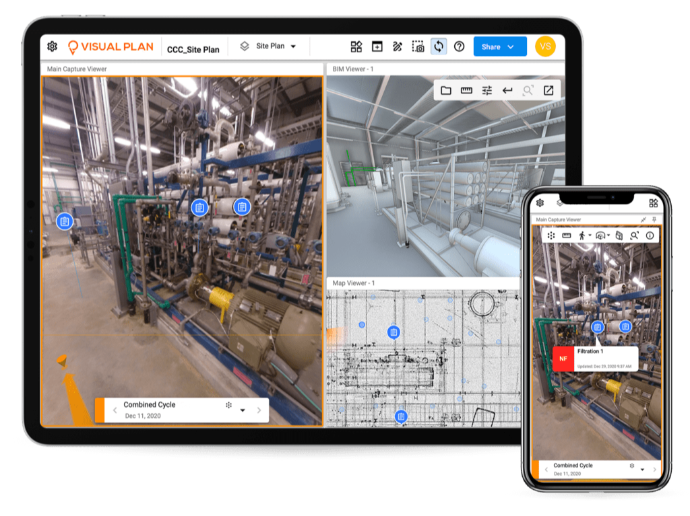
360° DIGITAL TWINS• Cloud based 360° capture engine stitches and processes equirectangular (panoramic) photos automatically • Immersive 3D Digital Twin • Spatial intelligence • Virtual tour with natural point-of-view movement |
ANNOTATION• Create a unique deep link URL to each annotation • Share-ability of annotation groups • Save view per annotation • Place annotations in-environment; include uploaded files, videos, hi-res still photos, create mark-up’s, dynamic notes, embed videos • Dynamic extended annotation and notification integration options |
POINT CLOUD IMPORT• Import Lidar files from supported file types: .las, .laz, .ply, .pts, .xyz, .rcp, .rcs, .obj (coming soon) |
AUGMENTED REALITY TRANSFER• Overlay BIM objects onto panos in-environment • Visual clash detection from BIM to Lidar, or 360° images • Object layout to compare with as-built conditions |
3D BIM/CAD IMPORT• Supported file types: .bcf, .rvt, .nwd, .ifc, .dwg • GIS satellite overview with project map dashboard for all projects • JSON import |
EXPORTED HTML REPORT DELIVERABLES• Export annotation group reports for hand over deliverables upon project completion |
2D CAD/FLOOR PLAN IMPORT• Import CAD files from image, multi-page pdf, file formats • Supported file types: .png, .jpg, .pdf, .svg • 2D sketch and 3D/4D floor plan tracing • Room search-ability on 2D floor plan |
SECURE CLOUD STORAGE• Cupix has been developed on the AWS cloud-based platform allowing all data to be shared collaboratively with many stakeholders using highly secure roles and permissions. Data resides in the USA. Additional options available. Learn more about AWS security. |
iOS 3D Capture App
Full 3D cloud-based SAS platform to easily share secure data among internal and external stakeholders for effective digital asset management.
VIDEO CAPTURE• Capture quickly up to 7 mins of data at walking speed, accurately and controlling drift • Unlimited number of captures • GPS data and AI to remove distortions • For use indoors and outdoors |
OFFLINE CAPTURE APP• Geolocate imagery over preloaded CAD plans • No need for a wireless connection • Annotate and asset tag in the field • Take high resolution photos on your iOS device and embed still photos attached to annotations |
MULTI-SHOT CAPTURE• Simple, intuitive and fast capture • Unlimited number of captures • Captures automatically processed and organized in groups of up to 400 panos each • Panos are automatically processed, aligned and placed upon upload |
MOBILE DEVICE DETAILS• iOS Platform, support Version 13 or higher |
SINGLE-SHOT CAPTURE• Fast, minimum effort • Use confidently as a reference to pre-planning, or full capture • Simply drop a pano on the CAD anywhere you like |
APP SUPPORTED 360 HARDWARE/CAMERAS• Ricoh Theta Z1 (Fully Supported)• 360° photo and video supported• HDR Photo and Video processing on camera for cloud processing directly off of Capture iOS app. • MADV Madventure 360 / Xiaomi Mi Sphere• 360° photo and video supported• HDR photo and video supported with 3rd party stitching software desktop processing • Insta360 One R and One X • 360° photo and video supported |
Tools
Unique tools to increase digital asset management and operational efficiency.
DISTANCE, ANGULAR AND RADIUS MEASUREMENTS |
INTEGRATIONS• Procore • BIM 360 • PlanGrid • Bolt-on Connectivity to your favorite enterprise platforms: CAFM, CMMS, IWMS, EAM |
PANO EDITING TOOLS
|
CLOUD CONNECT DESKTOP• Upload panos and Lidar/Point Cloud into projects • Download SiteViews for offline access |
OUR AI-DRIVEN FEATURES |
OFFLINE DESKTOP VIEWER• View project SiteViews offline
|
Annotate, Measure, Share & Report
Trusted measurement with robust customized annotation form creator. Quick secure sharing and single click HTML/PDF report.
ANNOTATE• Add high resolution still images and video to enhance annotations• Mark-up 360 degree images using colors, circle, box, arrow, text, freehand scribble
•
Customize the built-in Digital Form Creation tool to add text, number, checkbox, dropdown, data and members assigned
|
SHARE & REPORT• Generate secure URLs for sharing among stakeholders; user access controls allow for permissions-based or public sharing• Additional exports in database format .xls, .csv for import to CAFM platform • Multi-directional URLs and integrations with CAFM platforms • Send Issues and RFIs directly to BIM360 and PlanGrid • Send RFIs, Observations, Punch Lists directly to ProCore • Export dynamic HTML reports for handoff deliverables |
MEASURE
•
Conduct 2D and 3D distance measurements on panos, BIM, 3D CAD and 2D floor plans.
|
FAQs
Trusted measurement with robust customized annotation form creator. Quick secure sharing and single click HTML/PDF report.
360 degree photos are common among recreational enthusiasts but can be extremely helpful in gaining a deeper understanding of what is happening in your environment. These special photos require a spherical camera creating a photo where you can view your environment as if you were standing in a room being able to see above, below and 360 degrees around. By using the Cupix platform, we import large amounts of 360 degree photos and stitch all these photos together to create an immersive environment. When stitching, we can apply intelligent scaling data over the stitch photos having 360 degree photogrammetry in our platform.
Photogrammetry is widely used in today’s industrial and commercial sectors to visually understand environments more clearly and be able to track progress over time, see facilities when a site visit is not possible or measure data when we need to verify something quickly saving time and energy.
Yes, Cupix’s unique platform provides clients with the ability to ingest all data you already have available or may be using, we just organize this data in a format that makes it readily available and easy to access for effective and efficient digital asset management. Once you have your data uploaded, if needed you can then conduct a capture of your environments to visualize, plan, develop and communicate.
A Digital Twin is an exact visual carbon copy or representation of a physical environment at a specific moment in time. Digital Twins incorporate a collection of photos, videos, 3D Lidar and other visual data to build your virtual environment. Click here to learn more about how Digital Twins can optimize your facility’s operation and maintenance initiatives.